Ron's Down River Report on Mountain Buzz
American Whitewater National River Database
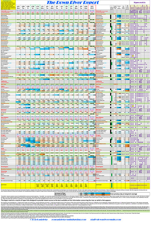
Check out our detailed River Flow Report before you head out on your next river trip. It summarizes the two most recent weeks of weather, snowpack and river flow data of interest to Western River runners (Colorado, Arizona, California, Idaho, Montana, New Mexico, Oregon, Utah, Washington, Wyoming & Texas). It is updated daily and reflects the most current river flows. The data is color coded to optimize the flow changes reflected in the report (Black indicates too low. Green indicates runnable. Red indicates to high for average fun; or flows considered unsafe except for true experts). Historical comparisons of snow pack and flows are included in this river flow report. With little imagination, the data observes near future flow predictions across the Western United States. Runnability determinations are based on in-depth research and personal experience. Don’t forget to check out the “Hyper-matrix” section on the far right of our river flow report. It is a matrix of hyperlinks designed to provide instant access to the best available on-line information concerning the river on which a link appears. All daily river flow data except the current date are averages reported in CFS unless otherwise noted. The current data is the instantaneous flow at the time indicated. River flow was sourced from the USGS unless noted (1-Colorado Division of Water Resources, 2-US Forest Service, 3-Poudre Rock Report). Colorado rivers are categorized north to south (west to east) to help, as possible, assist the analysis of weather systems that either add rain or temperature to runoff events. Feedback is welcomed and will be properly acknowledged.